Introduction: Reimagining Land Through Innovation
Across the globe, countries are facing mounting pressure from rapid urbanization, population growth, climate change, and shrinking natural resources. Coastal cities are expanding, agricultural demand is rising, and infrastructure needs continue to evolve. In response, engineers and environmental planners are increasingly turning to technology to transform unusable terrain into productive landscapes. The process of land reclamation has evolved dramatically over the past century, shifting from labor-intensive earthmoving operations to highly sophisticated, data-driven engineering projects.
Today, modern technology is not simply assisting reclamation efforts; it is redefining what is possible. From advanced dredging systems to satellite-guided precision mapping, digital modeling, and sustainable environmental controls, technology plays a central role in how land is restored, reshaped, and repurposed.
Understanding Modern Reclamation Projects
Historically, reclaiming land meant filling shallow coastal areas or draining wetlands to create space for agriculture or urban expansion. In earlier centuries, these projects were limited by manual labor, rudimentary tools, and minimal environmental oversight. The industrial revolution introduced mechanical dredgers and steam-powered equipment, but even then, the scale and precision were restricted.
In the 21st century, however, reclamation projects are complex undertakings that integrate civil engineering, marine engineering, environmental science, and geospatial analysis. Countries such as the Netherlands have long been pioneers in water management and land development, using advanced flood control systems and coastal engineering techniques to expand usable territory. Similarly, cities like Singapore have relied heavily on technological innovation to increase their land area while maintaining strict environmental standards.
Modern reclamation is no longer just about adding soil to water; it is about engineering stability, sustainability, and resilience.
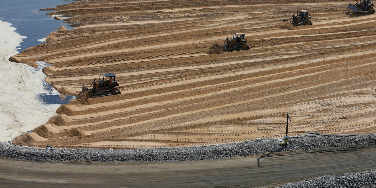
Advanced Dredging and Earthmoving Technologies
One of the most critical technological advancements in reclamation is the development of sophisticated dredging systems. Cutter suction dredgers and trailing suction hopper dredgers are equipped with GPS-guided navigation and automated control systems that allow for precise sediment removal and placement.
Companies such as Royal Boskalis Westminster and Van Oord operate some of the world’s most advanced dredging fleets. These vessels use real-time positioning systems, sonar mapping, and automated depth control to ensure accuracy within centimeters. This precision minimizes environmental disturbance while optimizing material use.
Modern dredging equipment also integrates sediment quality monitoring systems. Sensors can detect contaminants and ensure that dredged materials meet environmental standards before being redeployed. This reduces ecological damage and improves regulatory compliance, especially in environmentally sensitive coastal zones.
Geospatial Technology and Satellite Mapping
Before any soil is moved, planners must understand topography, seabed conditions, tidal patterns, and geological stability. This is where geospatial technologies have transformed the industry.
Satellite imagery from agencies such as NASA provides high-resolution data that allows engineers to assess coastal erosion, sediment transport, and climate risks. Combined with Geographic Information Systems and remote sensing technologies, this data supports detailed feasibility studies and environmental impact assessments.
In addition, Global Navigation Satellite Systems enable real-time positioning during construction. With centimeter-level accuracy, engineers can monitor elevation levels, compaction rates, and alignment throughout the project lifecycle. The integration of LiDAR scanning further enhances terrain modeling, producing three-dimensional maps that help planners anticipate potential subsidence or flooding risks.
This digital approach significantly reduces uncertainty and costly design errors.
Digital Twin Technology and Simulation Modeling
One of the most groundbreaking innovations in recent years is the adoption of digital twin technology. A digital twin is a virtual replica of a physical site, continuously updated with real-time data from sensors and monitoring systems.
Through advanced simulation software, engineers can model wave behavior, soil compaction, water flow, and structural stress before construction begins. These predictive models help identify vulnerabilities and test various scenarios, such as storm surges or sea-level rise.
For example, large-scale artificial island projects like Palm Jumeirah in Dubai required extensive modeling to ensure structural stability and long-term durability. Today, digital twins allow ongoing monitoring, enabling authorities to track settlement rates and shoreline changes over time.
This proactive approach enhances safety, reduces long-term maintenance costs, and supports adaptive management strategies.
Sustainable Engineering and Environmental Monitoring
Environmental concerns have historically been one of the biggest criticisms of reclamation activities. Wetland destruction, marine habitat loss, and altered hydrological patterns have raised serious ecological questions. Modern technology addresses these challenges through sustainable engineering solutions.
Sediment containment systems now use geotextile tubes and engineered barriers to prevent erosion and sediment runoff. Smart sensors monitor water quality parameters such as turbidity, salinity, and dissolved oxygen levels in real time. If thresholds are exceeded, construction can be adjusted immediately.
Artificial reef technology and habitat compensation strategies are also being integrated into project designs. By using ecological modeling software, planners can create replacement habitats that support marine biodiversity. This technology-driven environmental oversight ensures that development and conservation are no longer mutually exclusive.
In some regions, environmental monitoring is conducted in collaboration with international organizations like the United Nations Environment Programme, reinforcing global sustainability standards.
Automation, Robotics, and AI Integration
Automation has introduced new levels of efficiency and safety to reclamation sites. Autonomous bulldozers and remotely operated vehicles reduce the need for human operators in hazardous conditions. These machines use machine learning algorithms to optimize soil compaction and grading accuracy.
Artificial intelligence systems analyze vast amounts of geotechnical data to predict soil behavior under various load conditions. AI-powered risk assessment tools can identify potential instability long before it becomes visible on-site.
In countries like Japan, where advanced robotics are widely adopted in infrastructure projects, automation has significantly improved project timelines and reduced human error.
The integration of AI with IoT-enabled sensors allows continuous structural health monitoring. If subsidence or abnormal movement is detected, alerts are generated instantly, enabling preventive action.
Climate Resilience and Adaptive Design
As climate change intensifies, reclamation projects must be designed with resilience in mind. Rising sea levels and extreme weather events demand forward-thinking engineering.
Technological advancements now allow predictive climate modeling to inform project design. Coastal defense systems can be integrated directly into reclaimed areas, including smart sea walls and storm surge barriers.
The Delta Works in the Netherlands remains one of the most advanced examples of combining reclamation with flood protection infrastructure. Modern projects build upon similar principles but incorporate digital sensors, automated floodgates, and AI-driven forecasting systems.
By merging engineering innovation with climate science, technology ensures that reclaimed areas remain viable for decades to come.
Economic and Urban Development Impacts
Technology-driven reclamation has significant economic implications. It enables cities to expand without encroaching on agricultural or forested land. Urban planners can design smart cities equipped with integrated infrastructure from the outset.
In rapidly developing regions, reclaimed land often becomes the foundation for ports, airports, industrial zones, and residential districts. Advanced planning software ensures optimal land-use allocation, traffic modeling, and infrastructure integration.
In Singapore, technology-enabled coastal expansion has supported its transformation into a global financial hub. Without advanced engineering solutions, such strategic development would have been impossible within its limited geographic footprint.
The intersection of technology and urban planning ensures that reclaimed areas are not only functional but also sustainable and economically viable.
The Future of Technological Innovation in Reclamation
Looking ahead, emerging technologies promise even greater transformation. Blockchain-based project tracking could enhance transparency in large-scale infrastructure projects. Advanced materials science may produce stronger, lighter, and more environmentally friendly fill materials.
Renewable energy integration is also becoming a focus, with solar panels and wind turbines incorporated into newly created landforms. Real-time data analytics will continue improving maintenance and performance monitoring.
As computational power increases and environmental regulations tighten, technology will remain the backbone of responsible land development.
Conclusion: Engineering a Sustainable Tomorrow
The transformation of waterlogged, submerged, or degraded terrain into productive landscapes is no longer a purely mechanical task. It is a multidisciplinary, technology-driven endeavor that combines engineering precision, environmental science, and digital intelligence.
From advanced dredging fleets to AI-powered monitoring systems, modern innovations have reshaped how nations expand their territory and adapt to changing environmental conditions. Countries like the Netherlands and Singapore demonstrate that with the right technological framework, land expansion can be both efficient and sustainable.
Ultimately, technology does more than move earth and sand. It builds resilience, safeguards ecosystems, and shapes the cities of tomorrow. As global challenges intensify, continued innovation will determine how effectively humanity can create new space while protecting the planet’s fragile coastal environments.